
The weather across North India has taken a dramatic and shivering turn this weekend. A potent combination of Western Disturbances and cyclonic circulations has triggered a dual assault of heavy rainfall in the plains and intense snowfall across the Himalayan region. From the bustling streets of the national capital to the serene peaks of Himachal Pradesh and Kashmir, the winter of January 2026 has intensified significantly. This detailed report analyses the current meteorological situation, the forecast for the Republic Day weekend, and the impact on daily life, travel, and agriculture.
Delhi NCR: The Chill Returns After Record Rainfall
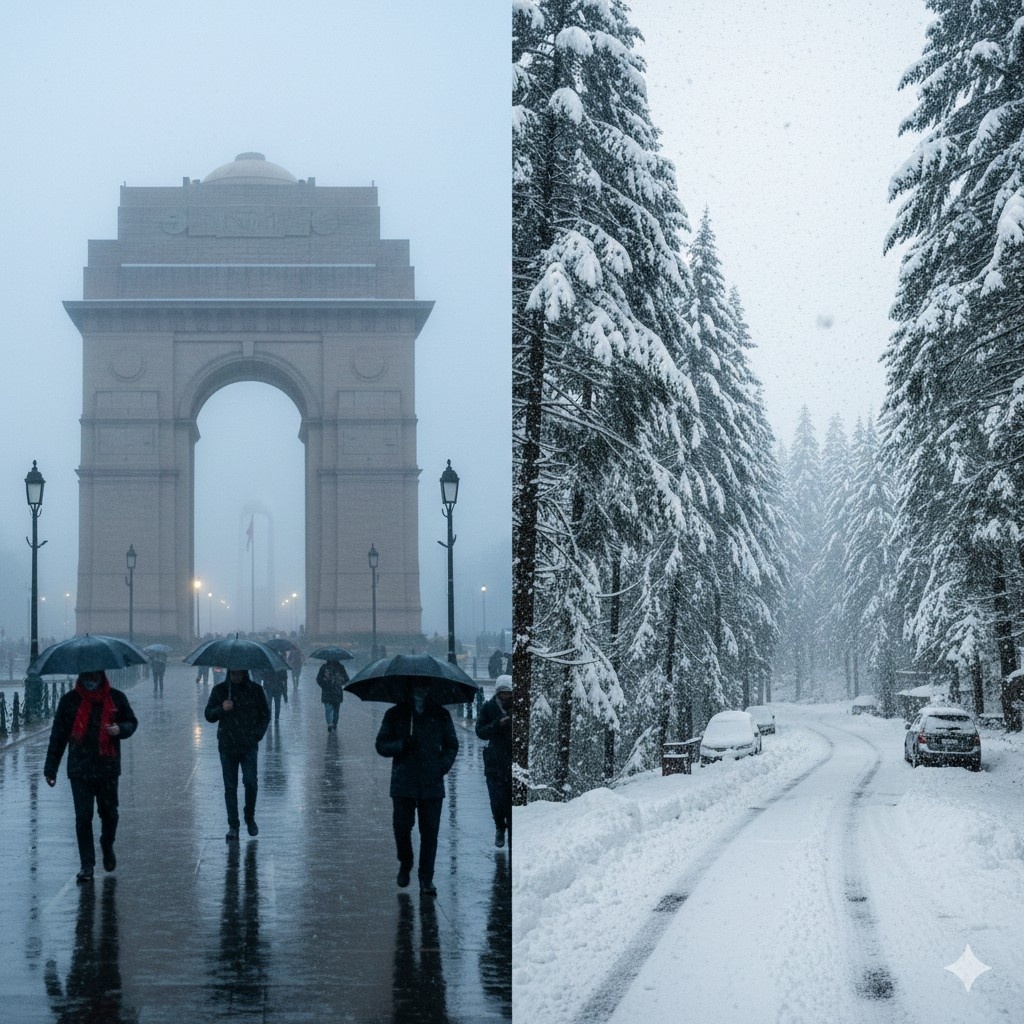
Residents of Delhi and the National Capital Region (NCR) woke up to a distinct chill in the air on Saturday, 24 January 2026, following a day of significant meteorological activity. Friday marked the wettest January day in two years for the city, a stark contrast to the dry spells often associated with this month.
According to the India Meteorological Department (IMD), the Safdarjung observatory, which serves as the primary marker for the city's weather, recorded 19.8 mm of rainfall. Other stations reported varying intensities, with the Ridge recording 23.2 mm and Palam recording 20.1 mm. This spell of rain was accompanied by gusty winds reaching speeds of 30 to 40 kilometres per hour, with isolated gusts at Palam airport clocking up to 37 kmph.
Plummeting Temperatures
The immediate aftermath of this rainfall has been a sharp decline in day-time temperatures. The maximum temperature in the capital nose-dived by approximately 11 degrees Celsius, settling at a shivering 16.0 degrees Celsius at Safdarjung, which is significantly below the normal average for this time of year. While the cloud cover caused the minimum temperature to rise temporarily to around 7.6 degrees Celsius on Friday night—making it the warmest January night in four years—this respite is expected to be short-lived.
Meteorologists warn that the moisture left behind by the rain, combined with clear skies anticipated from Sunday onwards, will lead to a rapid cooling of the surface. The IMD forecasts a fall in minimum temperatures by 3 to 5 degrees Celsius over the next few days. Consequently, the mercury is likely to dip below 4 degrees Celsius in isolated pockets, bringing back cold wave conditions to the region.
Fog and Pollution: A Mixed Bag
One silver lining of the gusty winds and showers has been a temporary improvement in Delhi's notorious air quality. The Air Quality Index (AQI), which had been hovering in the 'Severe' category, improved to 'Poor' and even 'Moderate' in some areas like Pusa. However, experts caution that this relief is transient. As wind speeds reduce and moisture levels remain high, pollution levels are expected to fluctuate between 'Poor' and 'Very Poor' in the coming days.
More concerning for commuters is the return of dense fog. The high humidity levels, recorded at 100 per cent at Safdarjung, have created favourable conditions for fog formation. The weather department has issued warnings for shallow to moderate fog during morning hours for the next week, with visibility potentially dropping below 200 metres in isolated pockets. This is likely to impact rail and road traffic, particularly during the early hours.
The Mountains: A Whiteout in Himachal and Kashmir
While Delhi deals with rain and chill, the situation in the higher altitudes of North India is far more severe. An active Western Disturbance has dumped heavy snow across Jammu and Kashmir, Himachal Pradesh, and Uttarakhand, painting the landscape white but paralyzing normal life.
Himachal Pradesh: Roads Blocked and Power Snapped
Himachal Pradesh has borne the brunt of this weather system. Reports indicate that life in the state has come to a standstill with over 500 roads blocked due to heavy snow accumulation. The State Emergency Operation Centre (SEOC) has confirmed that approximately 563 roads are currently unusable. This includes four National Highways, severely severing connectivity to remote tribal districts.
The Lahaul and Spiti district is arguably the worst hit, with nearly 290 roads closed, isolating the valley from the rest of the state. Vital arteries such as the Manali-Leh Highway (NH-03) and the road to the Atal Tunnel at Rohtang have been shut down as a precautionary measure. In the Chamba district, over 100 roads remain blocked, affecting the Pangi and Bharmour regions.
The infrastructure damage extends beyond transport. The heavy weight of snow on power lines and trees has led to widespread electricity disruption. As many as 4,797 distribution transformers across the state are currently unserviceable. Solan district alone accounts for over 1,800 damaged transformers, plunging large areas into darkness. The severe weather has also caused an estimated financial loss of over ₹6 crore to the state's infrastructure.
Despite the hardships, the tourism sector has seen a flurry of excitement. Famous hill stations like Manali, Dalhousie, and Dharamshala have received fresh snowfall, delighting tourists. Shimla, the state capital, recorded about 25 cm of snow, with temperatures struggling to rise above the freezing point. The maximum temperature in Shimla hovered near 0.6 degrees Celsius, turning the historic town into a winter wonderland, albeit a difficult one to navigate.
Jammu and Kashmir: Flight Operations Hit
Further north, the Union Territory of Jammu and Kashmir has experienced similar disruptions. The Srinagar airport saw the cancellation of multiple flights, including those operated by Indigo, due to poor visibility and heavy snowfall. The strategic Jammu-Srinagar National Highway (NH-44), the primary road link connecting the Kashmir valley to the rest of India, has been closed for vehicular movement due to snow accumulation and landslides in the Banihal sector.
Devotees visiting the holy shrine of Vaishno Devi in Katra faced challenges as the Trikuta hills received a fresh blanket of snow. While the visual spectacle is breathtaking, authorities have had to temporarily suspend helicopter services and restrict movement on certain tracks to ensure pilgrim safety. In the valley, famous tourist destinations like Gulmarg and Pahalgam have recorded significant snow depths, with Gulmarg registering over 50 cm of fresh snow.
Uttarakhand: Tourists Stranded
In Uttarakhand, the snowfall has been equally intense, particularly in the higher reaches of Garhwal and Kumaon. The temples of Kedarnath and Badrinath are covered in a thick layer of snow, with the Kedarnath temple premises reportedly under knee-deep snow. While this has enhanced the scenic beauty of tourist spots like Dhanachuli and Mukteshwar, it has also led to distress for travellers.
The State Disaster Response Force (SDRF) has been deployed to rescue tourists stranded in vehicles stuck in snow. In the Ramgarh and Mukteshwar areas, authorities used earthmovers to rescue 20 to 25 vehicles that were unable to move on slippery roads. The weather department has predicted that the snowy conditions will persist for another 24 to 48 hours, prompting advisories against travel to high-altitude areas unless absolutely necessary.
Meteorological Analysis: The Western Disturbance
The driving force behind this intense weather activity is a Western Disturbance—a storm system originating from the Mediterranean region that brings moisture-laden winds to the Indian subcontinent. The IMD explains that a cyclonic circulation currently lies over Jammu and adjoining Pakistan, extending up to the middle tropospheric levels. This system is supported by a strong subtropical westerly jet stream, with wind speeds reaching 130 knots (approx. 240 kmph) in the upper atmosphere over Northeast India.
Simultaneously, an induced cyclonic circulation has formed over north Punjab and heavy moisture incursion is taking place from the Arabian Sea. The interaction of these systems has resulted in the widespread precipitation observed over the last 24 hours. The trough from the cyclonic circulation has facilitated the transport of moisture deep into the plains, causing the rainfall in Delhi, Punjab, Haryana, and Western Uttar Pradesh.
Detailed Forecast: What Lies Ahead?
The India Meteorological Department has issued a detailed forecast for the coming week, covering the Republic Day celebrations and beyond. The outlook suggests that while the precipitation may reduce, the cold is here to stay.
Delhi NCR Forecast (25th - 30th January)
- 25th January: The sky will remain partly cloudy. Commuters should expect shallow to moderate fog in the morning. Maximum temperatures will hover around 18-20°C, while minimums could drop to 4-6°C.
- 26th January (Republic Day): For the parade and celebrations, the forecast predicts a partly cloudy sky with shallow to moderate fog in the morning hours. Surface winds will be calm in the morning, picking up slightly by the afternoon. Temperatures will remain cold, with lows of 4-6°C.
- 27th January: A fresh spell of very light rain or thundershowers is possible towards the afternoon or evening due to a fresh Western Disturbance affecting the region. This may be accompanied by gusty winds.
- 28th - 30th January: The sky will generally remain cloudy with persistent fog in the mornings. Temperatures are expected to see a gradual rise, with minimums returning to the 8-10°C range as the cloud cover traps outgoing heat.
Regional Warnings
The IMD has issued colour-coded warnings for several states. An Orange Alert (be prepared) has been sounded for heavy snowfall and rain in parts of Jammu & Kashmir, Himachal Pradesh, and Uttarakhand for the next 24 hours. A Yellow Alert (be aware) is in place for cold wave conditions in isolated pockets of Punjab, Haryana, Rajasthan, and Himachal Pradesh for the 25th and 26th of January.
Dense to very dense fog is likely to engulf Punjab, Haryana, and Chandigarh during the night and early morning hours of January 25th and 26th. This poses a significant risk for highway travel, and drivers are advised to use fog lights and drive with extreme caution.
Impact and Advisories
The severe weather has wide-ranging implications for various sectors, from agriculture to public health.
Agriculture
The heavy rainfall and hail pose a risk to standing crops. In Himachal Pradesh and Jammu & Kashmir, farmers have been advised to ensure proper drainage in wheat and mustard fields to prevent waterlogging, which can rot the roots. Orchard owners are advised to gently shake fruit-bearing trees to remove excess snow that could snap branches. In the plains of Punjab and Haryana, light and frequent irrigation is suggested during evening hours to protect crops from frost damage during the cold wave.
Health and Safety
The combination of cold temperatures and pollution can be detrimental to health. The dense fog contains particulate matter that can lodge in the lungs, exacerbating conditions for those with asthma and bronchitis. The IMD warns of potential eye irritation and shortness of breath due to prolonged exposure to polluted fog. Residents are advised to:
- Avoid outdoor physical activities during early morning hours when pollution and fog are thickest.
- Wear masks when venturing out to protect against pollutants.
- Ensure adequate warm clothing, particularly for children and the elderly, to prevent hypothermia as night temperatures drop.
- Use heating devices carefully and ensure proper ventilation to avoid carbon monoxide poisoning from coal fires or heaters.
Travel Advisory
With over 500 roads blocked in Himachal Pradesh and key highways closed in Jammu and Kashmir, tourists planning trips to the hills are strongly urged to check official road status updates before departing. The risk of skidding on frozen roads is high. In the plains, train delays due to fog are expected to continue, and passengers should track their train status in real-time. Flight operations at Delhi and Srinagar airports may face intermittent disruptions depending on visibility conditions.
Conclusion
As North India prepares to celebrate Republic Day, the weather gods have ensured a true winter experience. While the rain has washed away some of the pollutants in the capital, it has left behind a biting cold that will test the resilience of the residents. In the mountains, the "white gold" of snow brings joy to tourists but hardship to locals dealing with power cuts and blocked paths. With a fresh Western Disturbance approaching around January 26th, the volatile weather pattern is set to continue, keeping the region firmly in the grip of winter.


Community Insights